|
|
|
Hike Islands Philippines
The Cordilleras Mountains
The majestic mountains of the Philippines lie on its largest mountain range, the Cordilleras in Northern Luzon. With a total area of 18,300 km², the mountain range has been declared as an administrative region which includes the provinces of Benguet, Abra, Kalinga, Apayao, Mountain Province, and Ifugao. It is home to highland peoples who have developed a fascinating mountain culture which is manifest in the world-famous Rice Terraces. Tourists – local and foreign – are enchanted with the semi-temperate climate of the region, which is a refreshing change from the tropical lowlands. Pine trees, rolling slopes, and vegetable farms characterize much of the region’s landscapes. Ilocos Region, adjacent to the range, is included in this group because most of its mountains are contiguous with the range.
* Kibungan Highlands: Benguet / 1886m
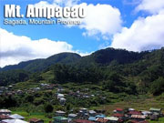
* Mt. Ampacao
Sagada, Mt. Province
Major jump-off: Ambasing Elementary School, Brgy. Ambasing, Sagada
Altitude: 1889 MASL (386 meter gain)
Days required / Hours to summit: Half day, 1.5 hours
Specs: Minor climb, Difficulty 2/9, Trail class 1,3
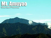
* Mt. Amuyao
Mountain Province
Jump-off points: Sitio Macalana, Barlig, Mt. Province; Batad, Ifugao
LLA: 17°10N, 120°57E, 2702 MASL
Days required / Hours to summit: 2 days / 5-7 hours
Specs: Major Climb, Difficulty 6/9, Trail class 3
* Mt. Amuyao/Traverse to Batad, Ifugao
Mountain Province and Ifugao
Entry point: Sitio Macalana, Barlig, Mt. Province
Exit point: Batad Junction, Banaue, Ifugao
LLA: 17.0123N, 121.1297E, 2702 MASL (#10)
Days required / Hours to summit: 3-4 days / 5-7 hours
Specs: Major climb, Difficulty 8/9, Trail class 1-3
* Mt. Kabunian: Benguet / 2000+m
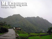
* Mt. Kapugan
Kiangan, Ifugao
Major jump-off: Brgy. Ambabag, Kiangan
LLA: 16°47'30"N 121°4'52"E, 1305 MASL
Days required / Hours to summit: Half-day / 2 hours
Specs: Minor Climb, Difficulty 3/9, Trail Class 3
* Mt. Lobo: Benguet / 2000+m
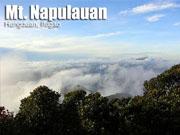
* Mt. Napulauan
Hungduan, Ifugao
Major jump-offs: Poblacion and Brgy. Hapao, Hungduan
LLA: 16°50′N, 121°10′E, 2642 MASL (#15; 1580m gain)
Hours to summit / Days required: 9 hours / 2-3 days
Specs: Major climb, Difficulty 7/9, Trail class 3
* Mt. Palemlem
Adams, Ilocos Norte
Major jumpoff: Sitio Maligligay, Adams
LLA: 1271 MASL
Days required / Hours to summit: 1-2 days / 4-6 hours
Specs: Major climb*, Difficulty 5/9, Trail class 2-3
Features: Tropical forest, Coastal views
* Mt. Patukan (Sleeping Beauty)
Kalinga Province
Major jump-off: Se-et, Tanudan, Kalinga
LLA: 17.28 N; 121.2 E; 1906 MASL (+1400)
Days required / Hours to summit: 7 days / 14-20 hours
Specs: Major Climb, Difficulty 9/9, Trail Class 6
* Mt. Pulag/Akiki Trail: Benguet / 2922m (#3)
* Mt. Pulag/Ambaguio Trail: N. Vizcaya / 2922m (#3)
* Mt. Pulag/Ambangeg Trail
Major jump-off: Ambangeg, Kabayan, Benguet
LLA: 16°34'58"N 120°53'15"E, 2922 MASL (#3)
Level and days required: Level 3, 3-5 days
Hours to summit / Days required: 4-5 hours / 2 days
Specs: Major Climb, Difficulty 3/9, Trail class 3
* Mt. Pulag/Tawangan Trail
Kabayan, Benguet
Major jump-off: Sitio Labang, Brgy. Tawangan, Kabayan
LLA: 16°34'58"N 120°53'15"E, 2922 MASL
Hours to summit / Days required: 10-11 hours / 3 days
Specs: Major Climb, Difficulty 6/9, Trail class 3
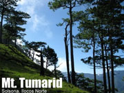
* Mts. Simagaysay-Tumarid Traverse
Solsona, Ilocos Norte
Major jumpoff: Brgy. Lomboy (?), Solsona
LLA: 1402 MASL (Simagaysay); 1560 MASL (Timarid)
Days required / Hours to summit: 3 days / 8 hours (S); 12 hours (T)
Specs: Major climb, Difficulty 7/9, Trail class 2-4
Features: Pine forest, Traverse trail, River crossing
* Mt. Cabuyao (2,025 +) / Mt. Sto. Tomas (2,256 +)
* Mt. Sto. Tomas
Tuba, Benguet
Major jump-off: Green Valley, Brgy. Dontogan, Baguio City
LLA (Mt. Cabuyao): 16° 21.530N, 120° 33.888E, 2025 MASL
LLA (Mt. Sto Tomas): 16° 20.12N, 120° 33.661E, 2256 MASL
Days required / Hours to summit: 1 day / 2 hours (ST) 3 hours (C)
Specs: Minor climb, Difficulty 2/9, Trail class 1
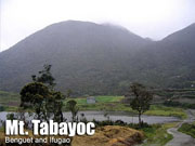
* Mt. Tabayoc
Benguet and Ifugao
Major jump-off: Brgy. Ballay, Kabayan, Benguet
LLA: 16.7000° N; 120.88333° E; 2842 MASL (#5)
Days required / Hours to summit: 2-3 days /4-6 hours
Specs: Major climb, Difficulty 6/9, Trail class 2-4
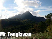
* Mt. Tenglawan
Tenglawan, Kabunian, and Lobo are provisionally assigned with the following Specs: Minor climb, Difficulty 5/9, Trail class 1-3.
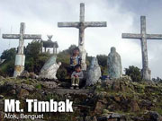
* Mt. Timbak (Singakalsa)
Atok, Benguet
Jump-off point: KM 55, Atok, Benguet
Elevation: 2717 MASL (#9)
Days required / Hours to summit: 1 day / 2-3 hours
Specs: Minor climb, Difficulty 3/9, Trail class 3
* Tirad Pass/Traverse - Sagada
Gregorio del Pilar, Ilocos Sur
Entry point: Poblacion, Gregorio del Pilar
Exit point: Polacion, Quirino, Ilocos Sur
LLA: N 17.08.43.5; E 120.38.02.4; 1312 MASL (HP)
Days / hours required: 2 days / 2 hours (shrine); 8 hours (traverse)
Specs: Major climb, Difficulty 5/9, Trail class 1-2, Historical trail
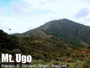
* Mt. Ugo
Nueva Vizcaya and Benguet
Jump-off points: Kayapa, N. Vizcaya; Brgy. Tinongdan, Itogon, Benguet
LLA: 16.31916°N, 120.80166°E, 2130 MASL
Days required / hours to summit: 2-3 days, 9-10 hrs
Specs: Major climb, Difficulty 5/9, Trail Class 1-3
|

 |